

By: Jeff Gunderman, Founder, DOOH Academy
The Latitude and Longitude (Lat/Long) is a standard location measurement in media planning. It is often required along with the street address of your media on plans, and it is used in planning platforms and DSPs as the primary location information of your media assets. Media planners and buyers use it to determine which units they will include in a plan.
When used correctly, Lat/Long gives the media planner or buyer a very accurate picture of the location of that piece of media. If the number is wrong, it can work against you and could exclude your media from buys where it should be included or alternately, could include your media on plans where it should not be included. For these reasons and more, it is important your lat/longs are accurate. In a digital planning world, you won’t typically be asked to provide relevant media based on location, the planner or buyer will just let the planning system or DSP select for them. You likely won’t even know the planner or agency is doing a particular campaign, so your media would just be left out of the plan.
Lat/Long can become inaccurate over time due to one or more of the following errors.
Entering the rate card info into the agency planning grid incorrectly.
One or both lat/long columns got out of sequence on the master rate card.
Data was not cut and pasted correctly.
Forgot to include the negative “-“, and the asset appeared to be across the globe.
Did not use the right number of decimals, so the location was not accurate.
In a digital planning world where your media is being brought into the plan through either a planning platform or DSP from an SSP, you eliminate most of the people errors inherent with manual cut and paste, but you also now have multiple master media lists you need to make sure are accurate and kept up to date. To some degree the old days of managing media on a master spreadsheet was easier as changes due to moving or adding a sign or corrections if something was not accurate only needed to be made to that one master that was housed by the publisher. In today’s digital world, many entities have their version of a media master list and so it is imperative you have someone in charge of insuring accuracy in each platform.
Some of the out of home media platforms that maintain their own media master and include Lat/long for each piece of media include:
AdQuick (SSP & Planning Platform - static & digital
Broadsign - SSP
COMMB, Canada (Measurement – static & digital)
DO Media (Planning Platform - static & digital)
GeoPath, USA (Measurement – static & digital)
Hivestack SSP
Move, Australia (Measurement – static & digital)
Place Exchange - SSP
Route, Great Britain (Measurement – static & digital)
VIOOH - SSP
Vistar Media - SSP
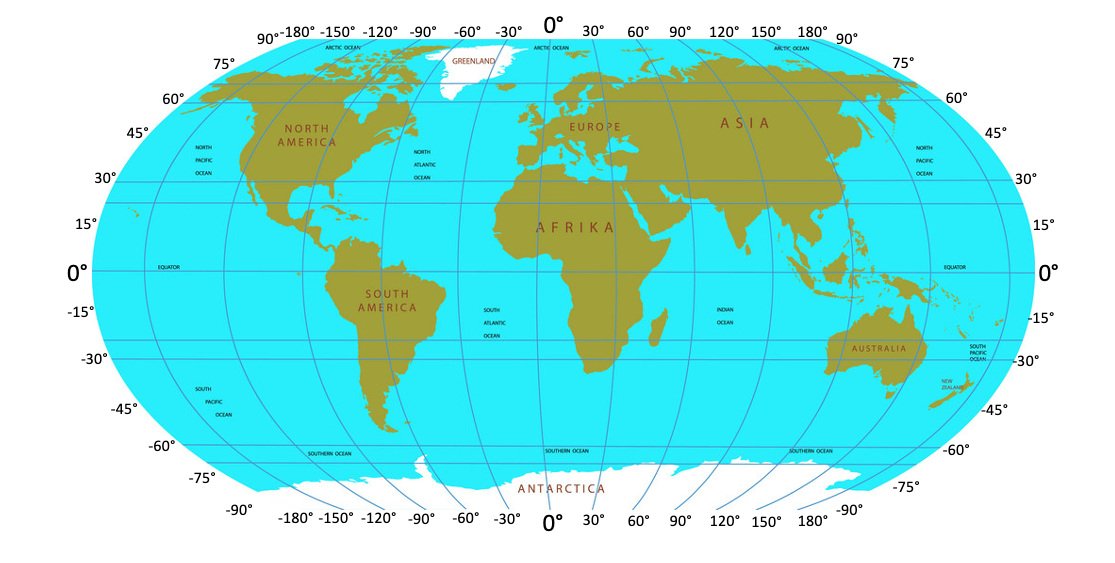
Let’s first understand Lat/Long and what the numbers mean.
Latitude and Longitude are a series of measurement lines that circle the earth east to west and north to south. Every location on the earth can be measured by the intersection of the east/west latitude line and the north/south longitude line. Each line is measured in degrees.
North to south (Latitude) is measured from the equator which is 0˚ to the North Pole which is 90˚N also written as 90˚ and to the South Pole which is 90˚S and written as -90˚. If the latitude is a positive number, it is north of the equator and if it is a negative number it is south of the equator. The thickness of each line or intersection of lines varies by the degree of accuracy.
East to west (Longitude is measured from its 0˚ point which is Greenwich, England. 0˚ is called the Prime Meridian. Longitude then increases from 0˚ to 180˚E written as 180˚ as you travel east from Greenwich and 0˚ to -180˚W written as -180˚ as you travel west from Greenwich. The point where the 180˚ east and -180˚ west come together is the international date line. Again, the thickness of each line or intersection of lines varies by the degree of accuracy.
Each degree of change in Latitude is equal to approximately 69 miles and each degree of change in Longitude is equal to approximately 54.6 miles. When looking at a Lat/Long number the numbers are written in degrees or decimals but in the media measurement world you will typically see them in decimals. For this reason, we use decimals to narrow down to more precise locations.
Each decimal place is essentially equal to dividing 111km by factors of 10, so 1 decimal place following the degree is accurate to 11.1km, 2 to 1.11km, 3 to 111m, 4 to 11.1m, 5 to 1.11m, 6 to 111mm and so forth. Most GPS devices are only accurate to 5 decimal places with some being accurate to 6. It takes special equipment to measure with the accuracy of 7 or more decimal places. In the media industry it is unlikely there would be a need to measure more accurately than 5 decimal places or within 1.11 meters or 3.6 feet. The trick however is to make sure the 5-decimal place number is accurate and if that is not, adding more decimals won’t help as the base measurement would be off, so you need to get this right. In fact, some platforms are now verifying media networks and this verification can include confirming accuracy of Lat/Long.
Many Publishers (Media Operators) keep a media master list on a spreadsheet or in a database. It is good practice to just have a quick look at your list on a regular basis and spot check locations to confirm accuracy. One trick is to remember if you are in the northern hemisphere your Latitude number will be positive between 0˚ and 90˚ and if in the southern hemisphere it will be negative between -0˚ and -90˚. Secondly if you are east of Greenwich, England your Latitude will be positive between 0˚ and 180˚ and if west of Greenwich it will be negative between -0˚ and -180˚. All media in the United States for instance will have a positive Latitude number and a negative Longitude number. Inaccuracy in Lat/Long could be as minor as your media being across the street or as major as being clear around the world. With data driven planning and more platforms verifying or certifying media, it is more important than ever to get these numbers right and to keep them updated as you move, replace, or add units.
A typical Lat/Long measurement will look like one of the following (Latitude is the first measurement):
Main Billboard in Piccadilly Circus, Westminster, London: 51.510240, -0.134567
Fountain in Piccadilly Circus, Westminster, London: 51.509919, -0.134448
Hotel Café’ Royal down the street in Piccadilly Circus, Westminster, London: 51.51019, -0.13633
If you only use 2-decimal places in the billboard example above, you would be in Leicester Square approximately 4-blocks away (1000 feet). If you use 3 decimal places you would be across the street approximately 200 feet away. If you accidentally made the Latitude a negative number, you would be in the South Atlantic Ocean between South Africa and Antarctica.
Note that on Google Maps some Lat/Long numbers go to 6 decimal places while others to 5. You will also notice that all three locations are at least 30 meters or more away from each other, but the decimals are the same to either 1, 2 or 3 decimal places. This is why a higher degree of accuracy is required.
So, pay attention to your Lat/Long’s and make sure someone on your team is responsible for keeping the platforms up to date.
Lastly, as a side note, Greenwich, England was chosen as 0˚ because of two factors. First, the USA used Greenwich as the basis for its time zone system and in the late 19th century a large percentage of the world’s commerce used sea charts in which Greenwich was the Prime Meridian or 0˚. This meant the largest number of people around the globe already referenced Greenwich as Prime Meridian. Additionally, On the other side of the hemisphere is the 180˚ longitude line where east and west longitude come together and is known as the International Date Line. This line divides the earth into eastern and western hemispheres. As you pass this line you either add a day if traveling west or subtract a day if traveling east.